
Tip 37: Finding matching external geometry in PhotoModeler
 In many photogrammetry projects you will use external knowledge to refine or add to the project. This external knowledge can be scale measurements, control points, survey data, CAD files, coordinate system definitions, point clouds, etc.
Three common forms of external information are: a known distance between two points to define an accurate scale, points selected to define the X and Y axes of the coordinate system, or multiple XYZ points marked from a survey to control scale and orientation.
PhotoModeler’s External Geometry Explorer (EGE) window is a powerful tool to keep track of all this external information. It is common to define (or import) a piece of external knowledge and then mark it or relate it to some points on the photographs.
PhotoModeler has tools for helping the user find these matches made previously (e.g. EGE objects matched to photo marks and vice versa).
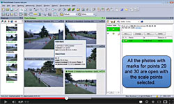 This image shows the EGE and some photographs open, and the command to show the matching scale points has been executed. The points that were previously matched are now highlighted in all windows so they are easily identified.
Similarly the video shows how to find the relationships you set up for an axes-based rotation, and for a 3D control point project.
Lastly, the video shows how to find the definition of a matching external object back in the EGE window, when you identify and select a point in a photo.