
With A Camera Perform Accurate and Detailed Surveying
 Surveying is an essential process in mapping, mining, construction, and architecture. This time and labor intensive process involves using a wide range of traditional and modern equipment to obtain measurements. Depending on the nature of the task, the required accuracy, and the challenges involved, a surveyor can use a tape measure/roller, a total station, a level, a laser scanner, or a photogrammetric tool. Most of today’s mapping, cadastral, and mining processes demand high accuracy surveys. Photogrammetry is a cost-effective method that also provides surveyors with accurate measurements. This technique entails generating models and measurements from photographic images. In this article, a few examples of the many uses of photogrammetric-based surveying are described.
Some mapping, mining, cadastral, and construction surveys are challenging and demand special measurement equipment. For instance, rock slope surveys involve taking measurements in terrains where it is difficult to use traditional tools. The photogrammetric technique enables surveyors to obtain accurate measurements in dangerous terrains and difficult to access locations. Unmanned aerial vehicle (UAV) photogrammetry provides reliable measurements that can be used for landslide characterization. Photogrammetric surveying is suitable for a wide range of applications including stock pile measurement, terrain analysis, urban planning, forest management, landfill monitoring, et cetera.
It is not easy to create accurate architectural restorations. When used in architectural surveying, photogrammetry provides visually realistic and accurate 3D models. This technique is, therefore, an unmatched choice for architectural modelling.
Rock slope surveys using photogrammetry
When a rock slope needs stabilization, a survey of its shape and size can help. Rock slope surveys are required to determine suitable locations for metal stanchions and the amount of mesh required for the entire slope. Using the total station method, this exercise can take days to complete. In some locations, rock slopes can be as high as 100 meters. This makes it difficult for surveyors to take

Figure 2: Catchment area with debris
measurements accurately and safely using total station setups. The photogrammetric method enables surveyors to obtain accurate measurements quickly and without exposing themselves to risks. In this paper published in the American Surveyor, a company that specializes in rock slope surveys uses PhotoModeler, a photogrammetric tool. This technique enables the company to improve accuracy of measurements and save time. After obtaining photographic images, the software automatically detects matching features in overlapping photos. As compared to traditional methods of surveying rock slopes, the photogrammetric method provides more detailed 3D descriptions, in less time, with less risk.
Surveying a landslide using unmanned aerial vehicle photogrammetry
The stability of a landslide can be calculated using numerical method or limit equilibrium method. To obtain accurate calculations, accurate landslide geometric descriptions are required. As compared to traditional methods or conventional photogrammetry, unmanned aerial vehicle (UAV) photogrammetry provides more accurate landslide geometric descriptions. This approach combines both aerial and terrestrial photogrammetry and provides surveyors with reliable measurements. The UAVs can be autonomous, semi-autonomous, or remote controlled. This article on surveying a landslide using aerial vehicle photogrammetry describes how this technique is used to obtain accurate and reliable measurements.
Architectural surveying using photogrammetry

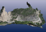
Figure 3: 3D model of a town
Photogrammetry allows creation of 3D architectural models that offer better perspective than ordinary maps or drawings. As compared to traditional methods of architectural surveying, the photogrammetric technique demands less time and effort and can produce interesting results with combined photographic textures. Figure 3 shows a 3D model of a historic town that was created using PhotoModeler. For architectural surveying, it is cheaper to use the photogrammetric technique than traditional surveying methods.
The second part of the American Surveyor article shows an architectural example using the method of photogrammetric survey for a redevelopment.
Conclusion
Photogrammetric surveying is a cost-effective method of obtaining accurate measurements from aerial or terrestrial photographic images. This technique is suitable for a broad spectrum of applications including terrain analysis, urban planning, architectural restoration, stability monitoring of structures, stock pile measurement, golf course layout, and so on. Aerial photogrammetric surveying enables surveyors to obtain accurate spatial information in high risk locations where traditional methods cannot be used. When used in difficult to access terrains, this surveying technique enables surveyors to take measurements with less effort. You can find more articles on photogrammetric surveying here.