How Does Photogrammetry Work?
- What Is Photogrammetry?
- Brief History of Photogrammetry
- Photogrammetry Locations
- Photography Essentials
- Uses for Photogrammetry
- How Does Photogrammetry Actually Work?
At PhotoModeler Technologies, we feel that the customers who get the most excited about our software are the ones who best understand the field of photogrammetry. This makes sense since the people with a foundational knowledge of photogrammetry will be in the best position to ask further questions about it and ultimately master the PhotoModeler software.
PhotoModeler Technologies’ core product is, of course, our photogrammetry software, which allows users to create accurate, high-quality 2D and 3D models from photos taken with their cameras. Photogrammetry is more than just an incredible technological concept. It also has plenty of practical applications in the real world, including in manufacturing, surveying, forensics, public safety, research, drone photography, film effects, and video game production.

Therefore, in this post, we’re going to explain how to capture photographs for photogrammetry and ultimately answer the question “how does photogrammetry work?” To all of our long-time customers, this is an introduction to a new series of articles on our website that will provide more background and educational material on photogrammetry, its applications, and how PhotoModeler products can help you in your photogrammetry pursuits. These articles won’t be laser-focused on the products themselves or their features, but we hope you find them useful as general photogrammetry resources.
With that said, let’s learn more about the exciting field of photogrammetry!
What Is Photogrammetry?
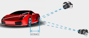
The word “photogrammetry’ itself derives from the parts “photo,” meaning “light”; “gram,” meaning “drawing”; and “metry,” meaning “measurement.” Distilled into the most basic of definitions, photogrammetry is the use of photographs to do measurement.
Someone wishing to employ photogrammetry to chart part of a mountain range, for instance, might fly above those mountains and take one photograph every few meters. Photogrammetry software then triangulates all those photographed points to create an accurate 2D or 3D map of the mountain range, with the distance between the points generated to scale. This explanation alone begins to reveal the many empirical uses of photogrammetry.
Brief History of Photogrammetry
All those readers who assume that photogrammetry is a product of the modern era of photography and computers might be surprised to learn that they are both correct and incorrect. Although digital photogrammetry originated in the 1980s, notable Italian Renaissance artist and inventor Leonardo da Vinci recorded in 1480 his own theory of how perspective should be incorporated into illustrations, i.e., that vanishing points must appear smaller, and the objects that grow out of them larger, since these objects are meant to be closer to the eye. In the 1850s, French scientist Aimé Laussedat pointed out the potential for mapping from photography, and he is today often considered the “father of photogrammetry.” The world community soon began to note the practical uses of photogrammetry, and people started experimenting with the technology during World War I and World War II.
Other, more modern efforts occurred throughout the twentieth century. Analytical photogrammetry, in which computers were used to solve complex mathematics, was made practical in the 1950s by Uki Helava. The advent of digital cameras in the early 1990s brought photogrammetry into the modern era, with both imaging and computations done digitally. Today, of course, people anywhere can acquire photogrammetry software such as PhotoModeler and use it for their own purposes.
Photogrammetry Locations
The photography needed to perform photogrammetry work can be conducted in different locations. It has traditionally been done from the air, but planes or drones are not required to work in photogrammetry. Since photogrammetry has so many real-world applications, photography can be done from several types of location.
Aerial Photogrammetry
Individuals wishing to employ photogrammetry using aerial photographs mount a camera on the bottom of a plane or UAV/drone and point it either directly down to the ground or at a slight angle. The camera takes numerous photographs of each area of ground as the plane travels, with overlap among the photos. These images will form the basis of the map models created later using photogrammetry software.
Land Photogrammetry
The photos used in photogrammetry can also be taken directly on the ground or from a fixed terrestrial position, such as by a person walking around or a camera mounted to a building.
Satellite Photogrammetry
A third major type of photogrammetry is conducted from photos taken in orbit from a satellite. While this is not an application to which the general public has access, governments may use photos and other types of scans taken from satellites to triangulate points on large portions of the Earth. This type of photogrammetric location is a common source of data for Google Earth and Google Maps.
Photography Essentials
The nature of photogrammetry requires that the photographs be taken at the outset of the process be of the best possible quality. With that in mind, here are three major elements of good photographs that would be used in photogrammetry.
Image Quality
It stands to reason that if you want to extract quality data out of photographs, the photographs should be high quality. A quality photograph is well lit, has little to no blur (focus or motion-induced), has an appropriate depth of field, and is of sufficient resolution.
Positions and Angles
Some photogrammetric measurement can be done with a single photograph with suitable constraints, but projects are most often done with multiple overlapping photographs. There needs to be a separation in position and sometimes angle for the algorithms to reconstruct the geometry. Angles up to 90 degrees are not unheard of. Some forms of automated matching (such as PhotoModeler’s SmartMatch) require smaller angles between photos but still require the photographs to be from different positions.
Sufficient Field of View and Overlap
When working in photogrammetry, it is important for your camera to have the appropriate field of view. The subject needs to be covered while at the same time, keeping the resolution as high as possible. These are conflicting requirements. To overcome this, overlapping photographs are used. Each photograph can cover a small part of the scene or object but will overlap with other photos taken at different positions and angles.
Uses for Photogrammetry
With all this said, how might PhotoModeler software be right for you? Depending on the industry you’re in, our products allow you to create accurate, high-resolution models of everything from natural landscapes to crime scenes to boat covers. Your work might be in mining, surveying, forensic photography, or manufacturing. Photogrammetry software from PhotoModeler can help with all of this.
With your 3D models completed, you can examine scaled, fully detailed scenes of areas you photographed from all the proper angles. Imagine studying these scenes and models from literally all sides from the convenience of your computer. That’s the power of photogrammetry.
How Does Photogrammetry Actually Work?
With all that said, how does photogrammetry itself actually work? How can software extract 2D and 3D models from photographs? The short answer is that photogrammetry works by using 3D geometry, but let’s talk about what that means.
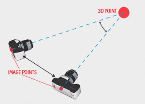
Look at a photograph you’ve taken for the purposes of photogrammetry. Every point in the photo defines a light ray in 3D space that starts at the camera and extends out to the real point. However, our software still needs more information from the photograph, namely the position and angles of the camera for each photograph and the camera characteristics of focal length, pixel size, and lens distortion.

With this information and a point identified on two or more photos, our software finds the geometric intersection of the light rays and figures out where that point is located in 3D space. Finding two or more points on the photos that correspond to the same 3D location is called “point matching” – this can be done manually or automatically. The light rays meeting up is called “ray intersection.” The overall method of using multiple photos for solving points is called “triangulation.” PhotoModeler software uses two algorithms–called “bundle adjustment” and “camera auto-calibration”–to decipher camera locations, angles, and characteristics when given just a few point matches. The result, of course, is that our software creates lines, surfaces, texture-maps, and full 3D models once it has the 3D point locations.

There are also photogrammetric techniques that work with single photographs, if necessary. For example, you can determine the height of a robbery suspect in a single frame from a security camera if you know other data about the scene. Yes, photogrammetry has more uses than you perhaps ever imagined.
We hope this guide has given you an overview of what photogrammetry involves and how PhotoModeler can help. Visit our FAQ or photogrammetry software products pages to learn more about who we are and what we offer. To get in touch with PhotoModeler with specific questions, contact our corporate office at sales@photomodeler.com.
