
PhotoModeler Premium Comparison in UAV Work
PhotoModeler Premium can be used for UAV / drone platforms for generating surface models, ortho-photos, or volume measurements.
The following lists the features that are included in PhotoModeler Premium (PMP), and that are not in PhotoModeler Standard.
| Powerful UAS-Focused Processing | |
| The process that takes images as inputs and produces accurate 3D and map data as output, has powerful capabilities that make more UAS projects possible. For example, the processing has new capabilities to handle GPS data from your UAV to improve accuracy, and speed (e.g. a 230 photo project to mark, match & orient takes 1.5 hours, but only 45 mins in PMP). | |
| Volume Objects | |
| Easily model and measure stock piles or other similar terrain shapes, and obtain accurate volumes. (see image below) | |
| Multispectral Image Support | |
| In agriculture and biological fields create and export 3D models or ortho-mosaics with draped multispectral image analyses such as NDVI, CIR, G-NDVI, and SAVI. Multi-spectral capability is for cameras with one lens and aligned multi-spectral channels. | |
| Geographic Coordinate Systems | |
| Import surveyor data, and export 3D and 2D data in a geographic coordinate system such as UTM, state plane or Latitude/Longitude. Work in a system compatible with your GIS or mapping system. | |
| PDF Report Generation | |
| Generate a nicely formatted summary report of the project in PDF format. Suitable for internal documentation or sending to clients. It is highly configurable. Here is a sample pdf report generated by PMP. | |
| Contours (major/minor) | |
| Create, display, overlay and export minor contours with a different look than major contours. A great visualization of height used by map makers. (see image below) | |
Sample Screen Shots
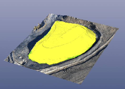
A 3D view of an extracted Volume Object on a stock pile.

A photo with 3D major and minor contours projected.