
Accident Scene Mapping with a Drone
PhotoModeler has been used since the early 1990s as a key tool in the accident reconstructionist’s toolbox. While much of this work is done with ground photography, the advent of drones / UAVs has made aerial mapping much more accessible. A drone can be flown over an accident scene to quickly capture all the details. Combined with some ground photos, this allows the scene to be cleared more quickly and the road reopened.
The results are accurate diagrams and maps of the scene, along with accurate distance and angle measurements that are important for the reconstructionist or the forensic specialist.
PhotoModeler specializes in working with small scenes such as city intersections and small roads. It can also work well in conjunction with sources such as security cameras, hand-held cameras, dash cams, and body cams. Projects are focused and typically under 100 photos (up to 200 photos in some cases). PhotoModeler is not a large area aerial mapping platform.
LIDAR scans are also being used in the field, and PhotoModeler can use this point cloud data to assist with reconstructions (useful esp. for photographs from unknown sources).
Below are some examples of simulated and real scenes, done fully or partially with drone / UAV photography. The first is an interesting application of using a drone at night, illuminated by vehicle headlights.
Sample Drone UAV Accident Reconstruction Projects
Nighttime Accident Scene from Drone
Can you do photogrammetry at night from a drone? It appears you can! In this case, the accident scene was illuminated by street lights and vehicle headlights. The DJI Phantom 4 Pro was flown in a circular orbit plus a small grid of nadir photographs.
The photos are grainy due to the low light but a SmartPoint cloud and surface were created automatically. A point cloud, texture surface model, and manual point and line CAD model were created.
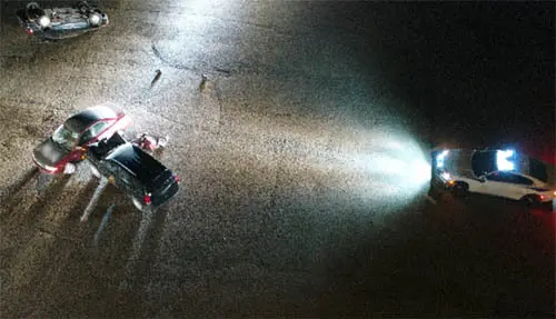
One of the convergent drone photos of the night scene.

3D View of textured surface model and drone camera positions.
A unique strength of PhotoModeler is its ability to easily add CAD data (points, lines, curves) to the model by identifying key points on multiple photographs. Here outlines were created on the two vehicles to help with the 3D reconstruction process.

CAD lines appear on the auto-extracted 3D surface of vehicles.
Drone photography courtesy of Air Access Solutions and Petauro Systems both of Colorado, and photogrammetric processing courtesy of DCM Technical Services of Ontario.
Bicycle Motor Vehicle Accident
In this sample, we have a collision between a cyclist and an SUV on a back road. The final resting positions of the bicycle and SUV were modeled, along with the skid marks.

Bicycle MVA photo with manual markings

Drone grid camera positions

Preliminary scene diagram
The Aeryon was flown in a larger grid pattern with nadir photographs combined with a partial circular orbit. A total of 164 photos were captured and processed.
Drone photography courtesy of Air Access Solutions and Petauro Systems both of Colorado, and photogrammetric processing courtesy of DCM Technical Services of Ontario.